From The Neolithic To The Sea: A Journey From The Past To The Present
High Falls Gorge
Statistics
Category
County
Coordinates
Grid
Condition
Age
Admission
County
Coordinates
Grid
Condition
Age
Admission
Gorge
New York
44° 20' 53.4" N 73° 52' 31.8" W
-
Good
Unknown
$
New York
44° 20' 53.4" N 73° 52' 31.8" W
-
Good
Unknown
$
Map
- History
- Gallery
- Gallery
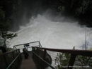
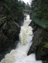
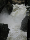
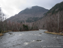
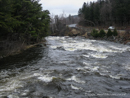
High Falls Gorge is situated on the west branch of the Ausable River. The river is one of New York States most famous trout streams. The Ausable River begins its exodus to the St. Lawrence Seaway on the side of Mt. Marcy, New Yorks highest mountain, only a short distance from the head waters of the Hudson. Unlike the south flowing Hudson, the Ausable journeys north. It also travels twice the distance to their mutual destination, the Atlantic Ocean.
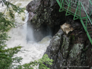
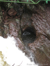
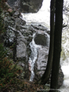
High Falls Gorge is composed of three basic and distinct rock types; blue grey anorthosite, pink granite and grey basalt. Two are layered horizontally and the third vertically. The powerful forces of earths upheaval over 1.5 billion years ago and temperatures of over 1000 degrees Fahrenheit created the rock striations and the deep crevasse seen here.
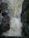
Sturdy bridges, walkways and groomed paths provide safe access to breathtaking views and photographic vantage points. High Falls Gorge is especially spectacular in the winter months. Come for a nature walk, and gasp at the spectacular ice formations on seven hundred feet of frozen waterfalls.
High Falls Gorge is composed of three basic and distinct rock types; blue grey anorthosite, pink granite and grey basalt. Two are layered horizontally and the third vertically. The powerful forces of earths upheaval over 1.5 billion years ago and temperatures of over 1000 degrees Fahrenheit created the rock striations and the deep crevasse seen here.
Sturdy bridges, walkways and groomed paths provide safe access to breathtaking views and photographic vantage points. High Falls Gorge is especially spectacular in the winter months. Come for a nature walk, and gasp at the spectacular ice formations on seven hundred feet of frozen waterfalls.