From The Neolithic To The Sea: A Journey From The Past To The Present
Burrough Hillfort
Statistics
Category
County
Coordinates
Grid
Condition
Age
Admission
County
Coordinates
Grid
Condition
Age
Admission
Hill Fort
Leicestershire
52° 42' 0.5" N 0° 52' 31.6" W
SK76081197
Fair
Unknown
Free
Leicestershire
52° 42' 0.5" N 0° 52' 31.6" W
SK76081197
Fair
Unknown
Free
Map
- History
- Gallery
- Gallery
- Gallery
- Gallery
- Gallery
- Gallery
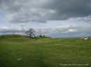
Burrough Hillfort is by the small village of Burrough on the Hill in Leicestershire.
Although the fort has not been dated with any certainty, archaeological evidence shows that the site was constructed about 200bc from pottery fragments. Later discovered remains include Romano - British pottery and Roman coins dating from the third and fourth centuries AD. It is probable that the site was occupied for at least 600 years. This fort was certainly built for defence, it is hard to tell if the site was permanently occupied or just used in times of crisis. The ramparts, constructed of large stones, a foot or so across, bedded in layers of clay would have been topped by a timber palisade fence with strong gates to close off the entrance. Over time the encircling ditches have become partially filled and the ramparts reduced by erosion. This process was aided in the seventeenth and eighteenth centuries by the removal of stone for road making. The defences are still very impressive, a formidable barrier to potential attackers.
Burrough Hill has a long history as a place for public recreation. In 1540 it was recorded by Leland that each Whitsuntide 'came people of the county thereabouts and shoot, run, wrestle, dance and use other feats of exercise'. In the 1800's the hill was the venue for the Somerby and Burrough Hill horse races. Whites directory of Leicestershire and Rutland of 1846 states that 'these races were established some years ago by the gentlemen at the Melton Hunt and usually excite great interest in the neighbourhood.' These events most likely took place within the ramparts which formed ideal vantage points 'affording to all the visitors a full view of the entire arena and giving to the whole the appearance of a complete amphitheatre.'
In 1960, an excavation on the left hand side of the entrance revealed a cobbled road surface and the foundations of what was probably a guard house. One of the most interesting finds were the unused quernstones now on display at the Jewry Wall Museum in Leicester. These are used for grinding corn.
Medieval ridge and furrow farming can clearly be seen all around the site. As early villages grew and forest cleared, the land was ploughed by oxen in strips which has left the pattern seen today. Soil was continually turned towards the centre of the strip, deepening furrows at the edges. By about 1350 the strip system was being replaced by hedged fields.
A toposcope is located on the south west bank, indicating the principal landscape features and their distance from Burrough Hill. A trig point can be found on one of the banks which is a fixed surveying station for geodetic surveying. The process of placing trig points on top of prominent hills and mountains began in 1935 to assist in the accurate re-triangulation of Great Britain directed by the cartographer and mathematician Martin Hotine. In low lying or flat areas some trig points may be only a few metres above sea-level. When all the trig points were in place, it was possible, in clear weather, to see at least two other trig points from any one trig point. Careful measurements of the angles between the lines-of-sight of the other trig points then allowed the construction of a system of triangles which could then be referenced back to a single baseline to construct a highly accurate measurement system that covered the entire country.